Winter is on the way, and the coming season’s weather pattern represents a big question mark for transportation and logistics pros. We hear weathermen discussing whether we will have an “El Niño” or a “La Niña” year.
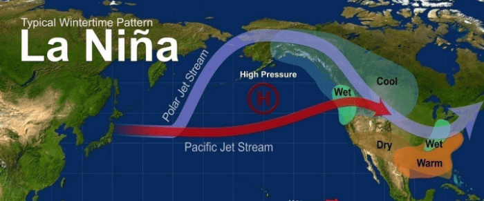
This winter has a 65% to 75% chance of continuing the La Niña conditions from last year. That means we can expect warmer, drier weather in the Southern band of states, and cool, wet weather in the North. The outlook for January through March shows a few areas of special concern for road warriors.
Find loads, trucks and lane-by-lane rate information on DAT load boards in any weather, including rates from DAT RateView.
What are El Niño and La Niña?
El Niño (“little boy” in Spanish) and La Niña (“little girl”) are opposite phases of complex weather systems that are influenced by sea surface temperatures in the central Pacific Ocean, near the equator. Fun fact: the name “El Niño” was coined by Peruvian sailors in the late 19th century because the weather pattern typically occurred during the Christmas season, according to National Geographic.
When there is no El Niño or La Niña, the normal weather pattern features surface winds along the equator that move warm water from South America to the west, towards New Zealand and Indonesia. A warm pool of water develops in the western Pacific, which creates an area of low pressure, with cloudy and stormy conditions. As the storms move eastward, rain or snow falls on the ocean. By the time that weather pattern gets to the eastern Pacific near South America, the resulting high pressure leads to relatively dry, cool conditions and cooler water.
La Niña in the U.S. – Dry in the South, Wet in Northwest and Midwest
During a La Niña event, stronger surface winds along the equator move warm water farther west than normal. This pushes colder water up to the surface of the ocean, off the west coast of South America. The colder water spreads westward along the equator, and sea surface temperatures drop in the central and eastern Pacific. High pressure forms off the South American coast, where drier conditions prevail. La Niña is the cold phase of the El Niño-Southern Oscillation (ENSO) cycle, due to the colder temperatures on the sea’s surface.
Both El Niño and La Niña peak during the winter, and both can significantly affect weather patterns around the world. With La Niña, the jet stream is pushed farther to the north. Drier conditions prevail in the South, with wetter conditions occurring in the Midwest and Pacific Northwest. Temperatures in the Southeast tend to be warmer with the Upper Plains being colder.
El Niño in the U.S. – Cold and Wet in the South, but Warm and Dry in Northwest and Midwest
In an El Niño year, the surface winds along the equator are too weak to push the warm water westward across the ocean. Instead, the warm water flows eastward on the surface, and it collects off the coast of South America. With higher sea surface temperatures in the central and eastern Pacific, low pressure forms, causing rain and storms. They move inland over the Americas. Since sea surface temperatures are warmer, El Niño is often referred to as the warm phase.
During an El Niño, the warmer and wetter conditions in the central and eastern Pacific shift the jet stream eastward in the Northern Hemisphere. In the United States, this results in wetter conditions to the Southeast and Gulf Coast, with drier conditions in the Pacific Northwest and Midwest. Temperatures tend to be higher than normal in the northern part of the country, with cooler than normal temperatures in the South.
Expect La Niña This Winter
La Niña conditions are most likely to prevail this winter, with warmer and drier weather in the South, but cooler and wetter weather in the North.
We had a La Niña winter last year, with atypical cold and snowfall in the Midwest, from northwest Ohio to northern Indiana and Illinois, up into Wisconsin and Minnesota. This year’s weather may not be as severe, but truckers will need to be aware of road conditions on Interstates 80 and 90 through those states, and there could be delays in and around Chicago, Indianapolis, Detroit, Milwaukee, and Minneapolis.
La Niña could also lead to a repeat of last year’s snowy winter in the Pacific Northwest, with heavier-than-normal rain and snow as far east as Montana. Interstate 90 runs through that area, as does I-5 in western Washington and Oregon.
There’s a bright side. Heavy snowpack in the Cascades and the Sierra Nevada range should set the stage for a more normal winter in California. Last year, extreme rainfall caused floods that delayed the planting season, but a more typical winter could lead to timely planting and harvesting, with improved crop yields in the spring. And skiers might enjoy above-average snowfall this winter in the Oregon, Washington, Montana, Wyoming, and Western Canada.
Regardless of the long-range forecast, it’s best to be prepared for anything. Always carry chains, a shovel, and emergency supplies, especially if you’re traveling through the mountains. Even when you drive a four-wheeler, if it might snow in your area, keep a shovel and an ice scraper in your car all winter. Listen to weather reports and try to avoid routes that may be subject to closure.
Stay safe out there!
Guest blogger Kevin Selfe holds a BSc in Meteorology from North Carolina State University in Raleigh. In addition to his meteorology credentials, Kevin is a professional blues singer and guitarist with Kevin Selfe and the Tornadoes.


